Date August 7, 2011
Day 40
Departure South Bay Cove Marina, Honey Harbor 9:30am
Arrival Henry’s Fish Restaurant, Frying Pan Island 1:45pm
Miles 28.1
Cumulative 866
The rain came last night and this morning it was still overcast, but the forecast was for partly sunny, so we headed off after refueling and having the head pumped. The scenery is spectacular; the pictures can’t relay the beauty of all the rocky islands. I have noticed a number of rock piles that look like the stones were purposely placed there. I have discovered these are called inukshuk and are based on Inuit Indian lore. They were used by the Inuit Indians to mark a place or point a direction. I think they are interesting and will try to add pictures of them as I find them.
Navigating is a little tricky, but the channels are well marked. Bob follows the route on the chart plotter, while Lynda is the backup using both Skipper Bob and paper charts. So far, so good! We have not made any mistakes and have arrived at each destination safely and without incident! We planned on stopping at Henry’s for dinner and staying the night. When we arrived, it was still early afternoon and our friends, Ken and Pinky from BraveHeart were just leaving. They had already had lunch and were heading out to Echo Bay to anchor for the night. We made plans to meet up with them tomorrow and travel together once again. Dinner at Henry’s was excellent. Both Bob and I had battered pickerel, fries, coleslaw, baked beans and a roll. I had never had pickerel (aka walleye in the US) and would not hesitate to have it again!
 |
| Inunshuk in Honey Harbor |
 |
| Rocky Georgian Bay coastline |
 |
| Another channel to navigate! |
 |
| Passing through another rocky channel |
 |
| Henry's Fish Restaurant |
 |
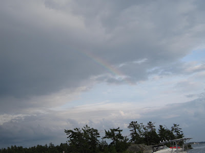
| A very small rainbow appeared (center of picture) after a brief shower\ |
 |
| Sunset at Henry's Fish Restaurant |


Where are you guys?
ReplyDelete